Advertisement: Explore the entirety of a canyon as it transitions between wide open dry riverbed and rocky narrows, into a network of gullies and canyons originating on the Grapevine Crest.
Some photographs as well as by Catherine Chen (most photographs below by C.C.).
Difficulty: 8.5 miles, 3000 ft to first camp, then about 11 miles, 4600 ft round trip to peak
Story: I first had the idea of hiking "all the way" up Fall Canyon after doing the day hike, seeing the dryfall, not continuing, then realizing that I could have. We attempted this canyon before, but our pace was far too leisurely that time. This time we made it out of the canyon into the mountains, but did not manage to summit Wahguyhe. We climbed a ridge to its south and admired it from there, about a mile south as the crow flies and 1700 ft below the summit.
Preparation: Here is a map I made that may help, and a very useful trip report by Steve Hall (see especially the map and also the "trip report format" which has photos; note that they enter from Titus Canyon which we did not).
We chose to camp deeper into the canyon this time, over the third dryfall. We used a rope to haul our packs over the dryfalls. If I were to attempt this again, I would likely choose a slightly warmer month with longer days (e.g. November) and camp just below the second dryfall to avoid the hassle of pack hauling.
Dryfalls: There are three dryfalls to surmount, which may be difficult with heavy packs.
The first one more or less must be bypassed, it appears unclimbable to all but possibly very expert climbers. The bypass is to the climber's right, a little bit further back along the canyon, and is often marked by a rock pile which one uses as a boost. The first move is an V0 bouldering move which might intimidate some due to the possible hard landing, but the hand-holds are excellent. We passed our our heavy packs from below via the obvious ledge to the right. From there it is just a walk over the dryfall.
The second dryfall appears climbable to the left, but we were unable to. We bypassed it to the right via the heavily talused slope. There is more or less one place where it is possible to climb over the wall to the climber's lift on this talus slope; be sure not to miss it. Though not technically difficult, this bypass involves some exposure and unstable footing. Getting over the cliff requires maybe a V1 bouldering move.
The third dryfall (which is really a chokestone) is immediately after the second and appears climbable from middle, but there is a bypass the right. This might make some nervous since there is some exposure with a hard landing, but the rock is stable.
The fourth dryfall is located near the end of the canyon. It can be directly climbed on its face.
Routefinding: The routefinding is easy and obvious until one exits the canyon. There, one is faced with branching canyons and different ridges. We had essentially followed the wrong canyon at some point and found ourselves on the wrong ridge (a blessing in disguise, since we were clearly not making our turnaround time and this ridge offered a very nice view of Wahguyhe itself). My suggestion would be to either bring a detailed topo map (need to print out from USGS, the National Geographic one is not sufficient) or download the map to a phone and use the GPS there.
Temperature: We hiked this in the winter in early January. The temperatures in the morning felt close to freezing (some breath frost on our tents) and the north slopes of mountains in the upper canyon all had snow. It was much colder than our previous attempt in early December (where I recall cool but comfortable temperatures), and it felt a bit like mountaineering where we essentially retreated into our tents at sundown. None of us were motivated enough to get an "alpine start" but that's essentially what we would have had to do to make our turnaround time.
Water: Possibly due to a recovering cold or poor fitness, I drank much more water on this attempt and also felt burned out due to the pack weight. Last time, in warmer weather, I carried 2.75 gallons and drank only 1.75 of it. This time, I carried 3.4 gallons and drank essentially all of it.
Summary: Seeing the canyon transition into the mountains was pretty cool. Would like another shot at the peak some day.
Some photographs as well as by Catherine Chen (most photographs below by C.C.).
Difficulty: 8.5 miles, 3000 ft to first camp, then about 11 miles, 4600 ft round trip to peak
Story: I first had the idea of hiking "all the way" up Fall Canyon after doing the day hike, seeing the dryfall, not continuing, then realizing that I could have. We attempted this canyon before, but our pace was far too leisurely that time. This time we made it out of the canyon into the mountains, but did not manage to summit Wahguyhe. We climbed a ridge to its south and admired it from there, about a mile south as the crow flies and 1700 ft below the summit.
Preparation: Here is a map I made that may help, and a very useful trip report by Steve Hall (see especially the map and also the "trip report format" which has photos; note that they enter from Titus Canyon which we did not).
We chose to camp deeper into the canyon this time, over the third dryfall. We used a rope to haul our packs over the dryfalls. If I were to attempt this again, I would likely choose a slightly warmer month with longer days (e.g. November) and camp just below the second dryfall to avoid the hassle of pack hauling.
Dryfalls: There are three dryfalls to surmount, which may be difficult with heavy packs.
 |
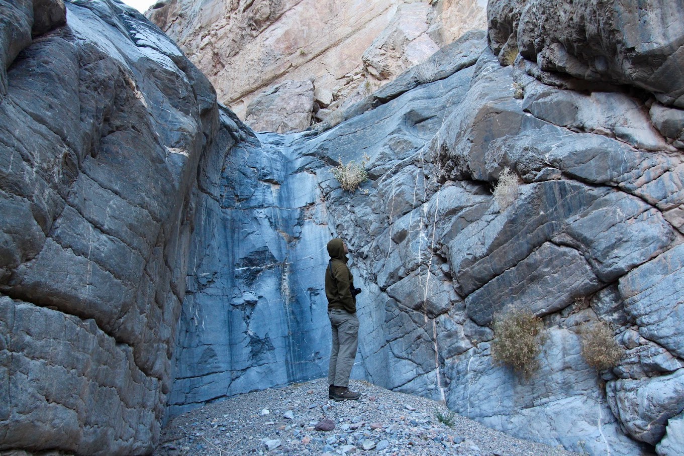
| First dryfall. |
 |
| Bypass to first dryfall. Notice the pile of rocks. Many dayhikers will use this to go into the narrows, but few go past there. |
The first one more or less must be bypassed, it appears unclimbable to all but possibly very expert climbers. The bypass is to the climber's right, a little bit further back along the canyon, and is often marked by a rock pile which one uses as a boost. The first move is an V0 bouldering move which might intimidate some due to the possible hard landing, but the hand-holds are excellent. We passed our our heavy packs from below via the obvious ledge to the right. From there it is just a walk over the dryfall.
 |
| Second dryfall. |
The second dryfall appears climbable to the left, but we were unable to. We bypassed it to the right via the heavily talused slope. There is more or less one place where it is possible to climb over the wall to the climber's lift on this talus slope; be sure not to miss it. Though not technically difficult, this bypass involves some exposure and unstable footing. Getting over the cliff requires maybe a V1 bouldering move.
 |
| Third dryfall (more accurately, chokestone), immediately after the second |
The third dryfall (which is really a chokestone) is immediately after the second and appears climbable from middle, but there is a bypass the right. This might make some nervous since there is some exposure with a hard landing, but the rock is stable.
 |
| Fourth dryfall near the end of the canyon. Directly climbable. |
The fourth dryfall is located near the end of the canyon. It can be directly climbed on its face.
Routefinding: The routefinding is easy and obvious until one exits the canyon. There, one is faced with branching canyons and different ridges. We had essentially followed the wrong canyon at some point and found ourselves on the wrong ridge (a blessing in disguise, since we were clearly not making our turnaround time and this ridge offered a very nice view of Wahguyhe itself). My suggestion would be to either bring a detailed topo map (need to print out from USGS, the National Geographic one is not sufficient) or download the map to a phone and use the GPS there.
Temperature: We hiked this in the winter in early January. The temperatures in the morning felt close to freezing (some breath frost on our tents) and the north slopes of mountains in the upper canyon all had snow. It was much colder than our previous attempt in early December (where I recall cool but comfortable temperatures), and it felt a bit like mountaineering where we essentially retreated into our tents at sundown. None of us were motivated enough to get an "alpine start" but that's essentially what we would have had to do to make our turnaround time.
Water: Possibly due to a recovering cold or poor fitness, I drank much more water on this attempt and also felt burned out due to the pack weight. Last time, in warmer weather, I carried 2.75 gallons and drank only 1.75 of it. This time, I carried 3.4 gallons and drank essentially all of it.
Summary: Seeing the canyon transition into the mountains was pretty cool. Would like another shot at the peak some day.
Comments
Post a Comment