Advertisement: Mt. Galen has some of the best views of the Alaska Range in the park. The mountain itself is not steep, rising gradually with a rocky summit reminiscent of the rocky moorlands of the British Isles (a place I have never been, so this is based on movies and pictures, mostly). The final summit block is a relaxing place to sit and rest.
More photographs.
Difficulty: 9 mile hike, 2000 feet of elevation gain. The distance you hike varies greatly depending on the route you choose, and whether you choose to hike along the road back to Eielson Visitor Center or wait along the road to be picked up.
Preparation: I learned of this hike from Ike Waits’ excellent Denali Guidebook. Other than studying the route on a map, there is no extra preparation for this hike. Gaiters might be useful for the creek crossing. Bears reportedly frequent the lower slopes of Mt. Galen. Be aware.
Red Tape
Check at the Backcountry Office near the Wilderness Access Center for any wildlife closures. It takes many hours on a shuttle to reach this hike, and it would be a bummer to ride that long to not hike.
Route
The trailhead is just west of Grassy Pass, near a “winding road” road sign. There is an obvious social trail through the initial thick brush to the north of the road. Ask to be dropped off here (the driver may know about this social trail). Though it’s recommended to avoid contributing to social trails, the lower brush is very thick and you may be forgiven for taking it to start the hike.
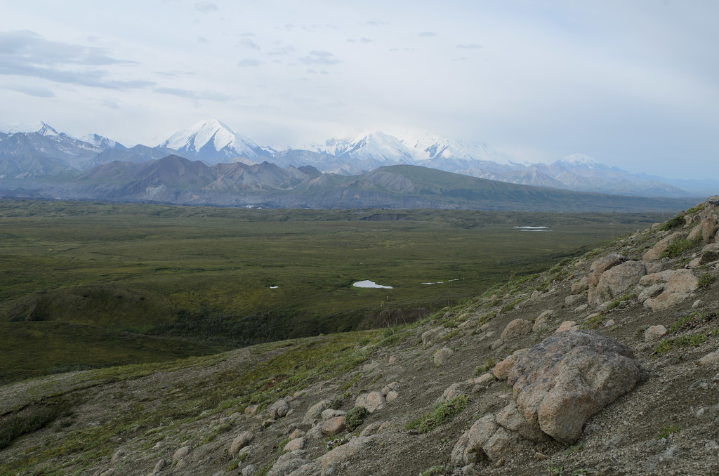
Once clear of the thick brush, you should be on the tundra table. Look up and identify the peak of Mt. Galen; it is unmistakable (see the above picture) for its two rock outcroppings at the summit block (though it will look very small from where you are). Keep your goal in mind; for much of this hike, you will have to balance taking the shortest distance-wise route to the peak with taking the easiest terrain-wise route.
If they are ripe, the blueberries can be eaten. The red berries might be soapberries, which taste like soap. They can also be eaten if you enjoy eating soap.
Make your way north over the table to Moose Creek. Be aware of small streams and muddy areas. Often you will have to choose between taking a circuitous route and bushwhacking. Once you reach Moose Creek, cross it. Though the creek is never too deep, I could not find a way to cross without either getting one’s shoes wet or taking them off. Look for a good way to ascend the shelf to the lower slopes of Mt. Galen. We took a circuitous route to the climber’s left; there is supposedly a shorter route to the climber’s right but we did not see an obvious one. Our route involved no bushwhacking on the way up; the climb was entirely on rock, dirt, and grass.
Once you make it on the shelf the rest of the hike is easy. Just hike toward the peak. Descending, be wary of taking “shortcuts.” What starts out as a nice grassy drainage can turn into thick brush with no escape. While the brush never traps you, it’s slow and annoying to hike through.
Summary: Hike this mountain for the views of the Alaska Range. The hike back to Eielson is also quite scenic. 5/5
 |
| Views from the lower slopes of Mt. Galen |
 |
| The peak of Mt. Galen, with its distinctive rock formations |
 |
| View from the summit |
More photographs.
Difficulty: 9 mile hike, 2000 feet of elevation gain. The distance you hike varies greatly depending on the route you choose, and whether you choose to hike along the road back to Eielson Visitor Center or wait along the road to be picked up.
Preparation: I learned of this hike from Ike Waits’ excellent Denali Guidebook. Other than studying the route on a map, there is no extra preparation for this hike. Gaiters might be useful for the creek crossing. Bears reportedly frequent the lower slopes of Mt. Galen. Be aware.
Red Tape
Check at the Backcountry Office near the Wilderness Access Center for any wildlife closures. It takes many hours on a shuttle to reach this hike, and it would be a bummer to ride that long to not hike.
Route
The trailhead is just west of Grassy Pass, near a “winding road” road sign. There is an obvious social trail through the initial thick brush to the north of the road. Ask to be dropped off here (the driver may know about this social trail). Though it’s recommended to avoid contributing to social trails, the lower brush is very thick and you may be forgiven for taking it to start the hike.
Once clear of the thick brush, you should be on the tundra table. Look up and identify the peak of Mt. Galen; it is unmistakable (see the above picture) for its two rock outcroppings at the summit block (though it will look very small from where you are). Keep your goal in mind; for much of this hike, you will have to balance taking the shortest distance-wise route to the peak with taking the easiest terrain-wise route.
If they are ripe, the blueberries can be eaten. The red berries might be soapberries, which taste like soap. They can also be eaten if you enjoy eating soap.
Make your way north over the table to Moose Creek. Be aware of small streams and muddy areas. Often you will have to choose between taking a circuitous route and bushwhacking. Once you reach Moose Creek, cross it. Though the creek is never too deep, I could not find a way to cross without either getting one’s shoes wet or taking them off. Look for a good way to ascend the shelf to the lower slopes of Mt. Galen. We took a circuitous route to the climber’s left; there is supposedly a shorter route to the climber’s right but we did not see an obvious one. Our route involved no bushwhacking on the way up; the climb was entirely on rock, dirt, and grass.
Once you make it on the shelf the rest of the hike is easy. Just hike toward the peak. Descending, be wary of taking “shortcuts.” What starts out as a nice grassy drainage can turn into thick brush with no escape. While the brush never traps you, it’s slow and annoying to hike through.
Summary: Hike this mountain for the views of the Alaska Range. The hike back to Eielson is also quite scenic. 5/5
Comments
Post a Comment