Advertisement: This short backpacking trip takes you directly into the rocky tablelands of Sequoia National Park. On the way you’ll camp in an alpine meadow, summit a rocky peak, and traverse backcountry terrain. The clear waters of Moose Lake, the feature of this hike, sits in a rocky basin with ample opportunities for free exploration.
More photographs.
Difficulty: Roughly 20 miles total, and 4000 ft of total elevation gain, but these numbers can vary depending on side trips and your chosen route.
Route
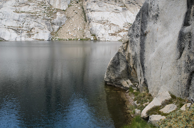
Bring a detailed map, and a compass, and use both. What follows is a sample itinerary for hiking this loop in the counterclockwise direction. On day 1, hike to Alta Meadow, set up camp, and summit Alta without your pack (camping in Alta Meadows). On day 2, head over to Moose Lake. There is no trail; my best advice is to use your compass and map to be sure of your bearings, and don’t gain too much elevation early on. If you gain too much elevation early, you will have to descend later as the ridges become too steep. From the meadow, you will cross two ridges into a valley with two small ponds. Moose Lake is above these ponds, north up the valley. Moose Lake is unmistakable: it is much bigger than the ponds you pass on the way. On day 3, exit the Moose Lake basin to the north; then head east (follow the ponds and seasonal creek washes) until you reach Pear Lake (Pear Lake is also unmistakable: it’s surrounded by steep smooth rock cliffs and lies snugly against the Alta mountains). When descending to Pear Lake, make sure you do so well on its north shore; if you descend on the wrong side, you may become trapped by a “nose cliff” which is impossible to wade around. Take the trail from Pear Lake back to the trailhead. One possibility is to make this a 4-day trip instead, and spend a day camped at Moose Lake to explore the tablelands. We did not have time for this.
Preparation: Permits are required; it is difficult to secure Pear Lake camping permits, so try Alta trailhead permits instead. Afternoon thunderstorms are frequent in summer months; when you see the storm clouds and thunder approaching, make sure you aren’t vulnerable to lightning strikes nor on rocks which may become slippery when wet, and possibly find a place to temporarily pitch some shelter. Bear canisters required.
Summary: Moose Lake is really a beautiful lake, and the tablelands are still enticing me to explore them. I can’t help but feel that I will be back. 5/5
 |
| Views on the way to Alta Meadow of the Great Western Divide |
 |
| Flowers, plants and grass in Alta Meadow |
 |
| Moose Lake at sunset |
 |
| Reflections on Moose Lake |
 |
| The impassable "nose" of Pear Lake |
More photographs.
Difficulty: Roughly 20 miles total, and 4000 ft of total elevation gain, but these numbers can vary depending on side trips and your chosen route.
Route
Bring a detailed map, and a compass, and use both. What follows is a sample itinerary for hiking this loop in the counterclockwise direction. On day 1, hike to Alta Meadow, set up camp, and summit Alta without your pack (camping in Alta Meadows). On day 2, head over to Moose Lake. There is no trail; my best advice is to use your compass and map to be sure of your bearings, and don’t gain too much elevation early on. If you gain too much elevation early, you will have to descend later as the ridges become too steep. From the meadow, you will cross two ridges into a valley with two small ponds. Moose Lake is above these ponds, north up the valley. Moose Lake is unmistakable: it is much bigger than the ponds you pass on the way. On day 3, exit the Moose Lake basin to the north; then head east (follow the ponds and seasonal creek washes) until you reach Pear Lake (Pear Lake is also unmistakable: it’s surrounded by steep smooth rock cliffs and lies snugly against the Alta mountains). When descending to Pear Lake, make sure you do so well on its north shore; if you descend on the wrong side, you may become trapped by a “nose cliff” which is impossible to wade around. Take the trail from Pear Lake back to the trailhead. One possibility is to make this a 4-day trip instead, and spend a day camped at Moose Lake to explore the tablelands. We did not have time for this.
Preparation: Permits are required; it is difficult to secure Pear Lake camping permits, so try Alta trailhead permits instead. Afternoon thunderstorms are frequent in summer months; when you see the storm clouds and thunder approaching, make sure you aren’t vulnerable to lightning strikes nor on rocks which may become slippery when wet, and possibly find a place to temporarily pitch some shelter. Bear canisters required.
Summary: Moose Lake is really a beautiful lake, and the tablelands are still enticing me to explore them. I can’t help but feel that I will be back. 5/5
Comments
Post a Comment